Club Directions / Maps
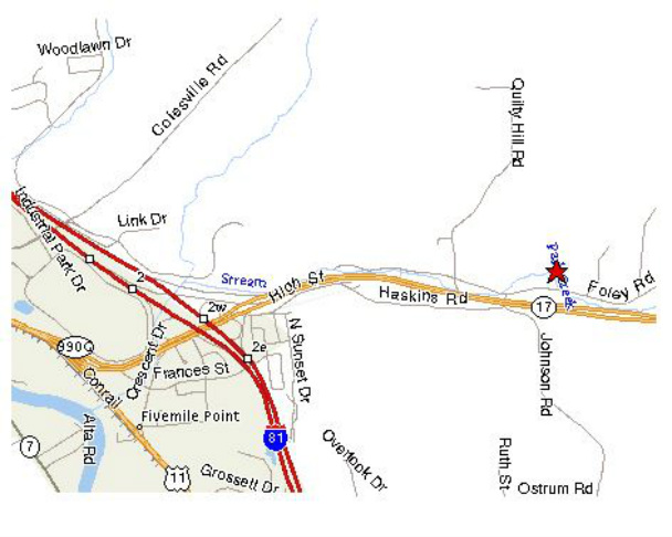
Directions to BCSA pistol range.
From points north, west, and south, take 81 to exit 2 and take 17 east.
Follow 17 east for just over a mile to Foley Road, exit 76.
Turn left at the stop sign at the end of the exit ramp and cross over 17 to Foley Rd.
Turn right and follow Foley for about 0.4 mile.
The club is on the left (north).
If coming from the east on rte. 17, take exit 76, Foley Road.
Turn right and follow Foley for about 0.2 mile.
The club is on the left (north).
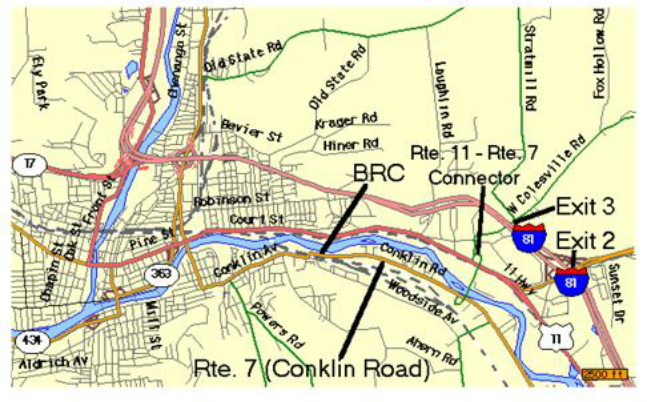
Directions to the Binghamton Rifle Club:
Latitude 42.10082N Longitude 75.86517W
The range is located on NY route 7 (Conklin Road) about 150 yards outside the Binghamton City Limits.
If approaching from the North, Northeast on I-88, or West on I-86 (NY17), take I-81 South and use exit 3, Industrial Park/Colesville Rd. Turn right on Colesville Rd. Turn left at the second traffic light (just past the Pilot Gas Station) and follow the signs to route 7. See *.
If approaching from the East, use I-86 (NY17) exit 75 to route 11 and proceed about 1.3 miles from the exit. Turn right at the first traffic light past the overpass and follow the signs to route 7. See *.
If approaching from the South, take I-81 North and use exit 2W to route 11. Proceed about 1.2 miles from exit 2W. Turn right at the first traffic light past the overpass and follow route 7 South signs. See *.
* Take the bridge over the river and turn left on route 7 North. The range is about 1.4 miles up route 7 on the right side of the road, the second building past Cottman Transmissions, sitting far back from the road.
The Club phone number is 607-722-1153. Call if you have problems.
Directions to New Milford Range – The Scenic Route
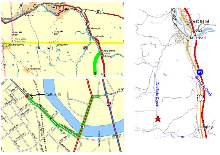
Choose A or B to get to DuBois St. in Hallstead, PA.
A - If coming from Binghamton Rifle Club, drive down routes 7 and 7a to Hallstead and turn right (West) onto SR 1037 (DuBois
Street).
1. From BRC go southeast on NY 7 (Conklin Rd) for 7.8 miles to NY 7A.
2. Southeast on NY 7A for 1.8 miles to PA 70. (Same road, different state.)
3. South on PA 70 for 2.3 miles. Becomes New York Ave in village of Hallstead.
4. South on New York Ave for 0.2 miles to PA 1037 (DuBois St).
5. Right (West) onto PA 1037 (DuBois St).
B - If you're coming from other areas, it would be faster to take NY 17E to US 81S to the Great Bend/Hallstead exit 230 (old 68).
1. Right (West) on PA 171 to US 11. (See Hallstead map at lower left.)
2. Left (South) on US 11 to Susquehanna Ave.
3. Right (Northwest) on Susquehanna Ave to Pine St.
4. Left (Southwest) on Pine St. to Church St.
5. Right (Northwest) on Church St for 0.23 miles to New York Ave.
6. Northwest on New York Ave and then left (West) onto PA 1037 (DuBois St).
_____________________________________________________________________
To get from Hallstead to the New Milford club you follow PA 1037 for 4.5 miles. You pass a couple of other gun clubs so be sure to
watch your odometer so you don't get the wrong one.
1. Go West (turns toward South as you leave town) on PA 1037 (DuBois St). (See map at right.)
2. After about 1.9 miles you come to a stop sign. Go straight across the intersection. PA 1037 becomes a dirt road. PA 1022 goes
to the right.
3. Continue South on PA 1037 for 2.6 miles. The club is on the left (east side of road).
If you get to the end of PA 1037 you went 0.3 miles too far.
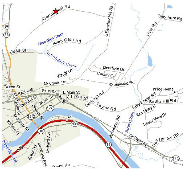
Directions to TCSA pistol range.
Take 17/86 to Owego.
Follow 38/96 north a little over a mile to Carmichael Road.
Turn right and follow Carmichael about 1 mile.
The club is on the left (north).
Take 17/86 to Owego.
Follow 38/96 north a little over a mile to Carmichael Road.
Turn right and follow Carmichael about 1 mile.
The club is on the left (north).
